Map unexplored territory
Create a map of an unexplored area like a backyard or classroom by measuring distances with steps, noting landmarks, drawing scale, and labeling features.

Step-by-step guide to map unexplored territory
Maps for Kids | Learn how to read a map and other skills in this fun introduction to maps
Step 1
Pick an unexplored area to map like your backyard or a classroom that you can walk around safely.
Step 2
Place a sticky note or small toy to mark your starting point.
Step 3
Choose which way will be “north” and mark that direction with another sticky note or a drawn arrow on the ground.
Step 4
Walk ten normal steps in a straight line from the starting point while an adult counts out loud.
Step 5
Put a sticky note where you stopped after those ten steps.
Step 6
Measure the distance between the starting sticky note and the ten-step sticky note with a tape measure or ruler.
Step 7
Divide that measured distance by 10 to find the length of one step and write that number down with adult help.
Step 8
Walk from the starting point to the first landmark while counting your steps out loud.
Step 9
Put a sticky note on that first landmark and write the number of steps you counted on the note.
Step 10
Walk from the first landmark to a second landmark while counting your steps out loud.
Step 11
Put a sticky note on the second landmark and write the number of steps you counted on the note.
Step 12
Walk from the second landmark to a third landmark while counting your steps out loud.
Step 13
Put a sticky note on the third landmark and write the number of steps you counted on the note.
Step 14
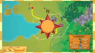
On your paper choose a map scale (for example 1 cm = 1 step), then draw your map using that scale, add the starting point and a north arrow, and plot and label every sticky-note landmark.
Step 15
Share your finished map on DIY.org
Help!?
What can we use instead of sticky notes or a tape measure if we don't have them?
Use small stones, coins, masking tape, or pieces of paper to mark the starting point and landmarks, and replace a tape measure with a ruler, a yardstick, or a printed ruler on paper to measure the distance between the starting sticky note and the ten-step sticky note.
What should we do if our steps aren't straight or we lose count while walking the ten normal steps?
Have an adult hold a string or walk a straight chalk line to keep your path straight, ask the adult to count out loud while you walk, and double-check the distance by measuring between the starting sticky note and the ten-step sticky note with the tape measure pulled taut.
How can we change the activity for younger or older children?
For younger kids, shorten the walk to five steps and let an adult write the step counts on each sticky note, while older children can use a compass to mark true north, record exact measured distances, and choose a detailed map scale like 1 cm = 1 step when drawing the map.
How can we make the finished map more interesting or useful before sharing it on DIY.org?
Personalize the map by drawing unique icons for each sticky-note landmark, adding a north arrow and a legend, color-coding paths, labeling measured step distances to scale, and gluing photos of the landmarks to the paper before you share the finished map on DIY.org.
Watch videos on how to map unexplored territory
What are Maps? - Learn & Grow Kids Geography Lesson | LeapFrog
4 Videos
What are Maps? - Learn & Grow Kids Geography Lesson | LeapFrog

Mapwork | Geography for Kids | STEM Home Learning
All About Maps - 4th Grade Social Studies | Let's Learn GA!
World Map Learning for Kids | Countries, Capitals Explained with Mapology
Facts about mapmaking and surveying
🗺️ Cartographers use a map legend to explain symbols — a tiny tree might mean a grove, and a blue line usually means water.
🧭 A compass needle points to magnetic north, which can differ from true north by several degrees depending on where you are.
📏 Map scale shows size relationships: 1:100 means 1 cm on the map equals 100 cm (1 meter) in real life.
👣 You can measure with steps — many people use a pace of about 0.7–0.8 meters (2.3–2.6 ft) to estimate distances.
🌍 Old maps can be time capsules: they sometimes show places that have changed a lot or no longer exist.
How to map an unexplored area like a backyard or classroom?
What materials do we need to create a map of unexplored territory?
What ages is this mapping activity suitable for?
What are the benefits, safety tips, and variations for this mapping activity?
